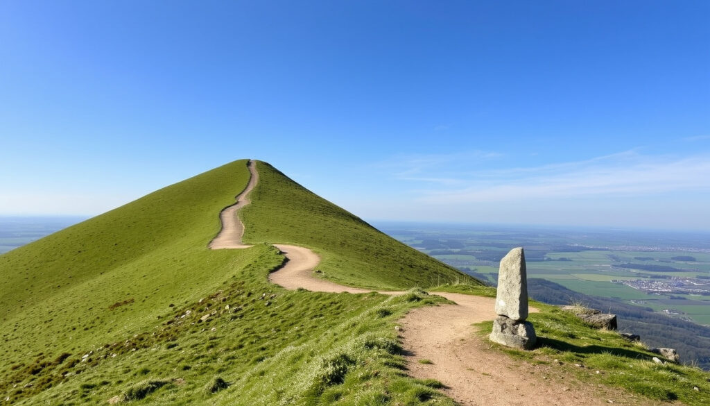
Roseberry Topping Walk: Route, Parking, Height & FAQs
There’s a reason the triangular peak of Roseberry Topping keeps pulling walkers off the A172. It isn’t the height—just 1,049 feet—but the way it suddenly rises from the North York Moors, daring you to find the path up.
Height: 1,049 ft (320 m) ·
Duration: 1.5–2 hours ·
Route length: ~5 km (3.1 mi) circular ·
Difficulty: Moderate (steep summit) ·
Car park postcode: TS9 6QS
Quick snapshot
- Height is 1,049 ft (320 m), per Redcar & Cleveland (local authority).
- An outlier of the North York Moors near Great Ayton, per Wikishire (geographic wiki).
- Circular route from Great Ayton is ~5 km with ~207 m elevation gain, per National Trust (walk route page).
- Exact parking charges vary and should be confirmed on-site. (National Trust (site owners))
- Car park postcode is listed as TS9 6QR by the National Trust (site owners), but widely cited as TS9 6QS.
- National Trust’s exact acquisition year needs a primary source confirmation. (National Trust (site owners))
- Medieval period: earliest recorded name ‘Othenesberg’, indicating Old Norse origin, per Wikipedia (historical place-names entry).
- 18th century: legendary local James Cook grew up in Great Ayton, per local history sources. (Wikipedia (historical place-names entry))
- 20th century: National Trust takes on management of the site, per National Trust (official site). (Wikipedia (historical place-names entry))
- Check the weather and arrive early to secure parking.
- Follow the National Trust route markers for the woodland wildlife walk.
- Tag photos with #RoseberryTopping to share the view with the online community.
Eight key numbers, one takeaway: the hill is short enough for a morning lark but steep enough to earn its reputation.
| Fact | Detail |
|---|---|
| Height | 1,049 ft (320 m) |
| Location | Near Great Ayton, North York Moors, North Yorkshire |
| Nearest car park | Newton-under-Roseberry (National Trust) |
| Circular distance | ~5 km (3.1 mi) |
| Elevation gain | ~207 m (679 ft) |
| Typical time | 1.5–2 hours |
| Difficulty | Moderate; steep summit section |
| Car park postcode | TS9 6QS (verify before travel) |
How long does Roseberry Topping take to climb?
The standard circular route from the Newton-under-Roseberry car park is roughly 6.5 km (4 miles) and takes two to three hours, according to Visit Tees Valley (local tourism partnership). Most visitors complete the summit section and return via the eastern descent in about 1.5 to 2 hours. Shorter options start from Great Ayton (~5 km / 3.1 miles circular) with an elevation gain of about 207 m (679 ft), as mapped by the National Trust (walk route page).
How hard is it to climb Roseberry Topping?
- Most official sources, including Visit Tees Valley (local tourism partnership), rate the full circuit as strenuous mainly because the final 100 metres of summit path are steep and loosely pitched stone.
- The main ascent from Newton Wood is a well-graded stone track, but the final scramble to the trig point requires confident footing and moderate fitness. AllTrails (user-led trail database) community ratings often place the difficulty at moderate to hard due to this section.
- The alternative base-level woodland walk published by the National Trust (woodland wildlife walk) avoids the steep climb entirely and is graded as easy.
If you can manage a flight of stairs without a pause, you can probably handle the summit push. If you are carrying a toddler or a heavy pack, stick to the base loop.
The pattern is clear: the hill’s relatively modest statistics line is misleading. The steep summit section concentrates a lot of effort into a short distance, which means the walk is shorter than many day hikes but punchier.
What is the walking route to Roseberry Topping?
What are some good walks around Great Ayton?
Three main routes, one start-point strategy: the Newton-under-Roseberry car park is the key to the summit. From there, Visit Tees Valley (local tourism partnership) describes the standard circuit: follow Roseberry Lane uphill for 400 metres, enter Newton Wood via steps and a kissing gate, then ascend the stone-pitched path to the summit ridge. The descent runs down the eastern face, passes Little Roseberry, crosses Newton Moor, and continues through Hutton Cowcross Woods before returning to the lane.
From Great Ayton, the National Trust (Great Ayton station route) outlines a 7.2-mile loop that includes Captain Cook’s Monument and Roseberry Topping. It begins at the village green and uses the Cleveland Way. A shorter option connects the hill directly to Captain Cook’s Monument via Gribdale, where roadside parking is available.
Arrive before 9:15 a.m. on a Saturday or be prepared to park at Great Ayton station and walk the extra kilometre. The car park at Newton-under-Roseberry fills fast.
The implication: the walk itself is straightforward, but choosing the right starting point determines whether it feels like a quick summit snatch or a full moors immersion.
How high is Roseberry Topping in feet?
Roseberry Topping stands at 1,049 ft (320 m) above sea level. According to Redcar and Cleveland Borough Council (local authority tourism page), the hill is an outlier of the North York Moors near Great Ayton, and its distinctive, near-conical profile makes it a landmark visible from across the Tees Valley. Despite its modest height, the hill feels taller because it rises directly from the relatively low-lying Cleveland Plain. Wikishire (geographic wiki) notes this topographic prominence gives it the presence of a much bigger hill.
The implication: the numbers are modest, but the visual impact is disproportionate—a trick of topography that gives Roseberry Topping its iconic status.
How much is it to park at Roseberry Topping?
What is the postcode for Roseberry Topping? / How to get to Roseberry Topping?
The main pay-and-display car park is at Newton-under-Roseberry, managed by the North York Moors National Park Authority. The National Trust (official site) states that parking charges apply to all users, including National Trust members. Charges vary seasonally, so check the signs on arrival.
The postcode for the car park is widely cited as TS9 6QS. The National Trust lists it as TS9 6QR for its own route maps. It is worth inputting both into your sat nav or using the what3words location (///collected.reasoned.scare). The nearest railway station is Great Ayton on the Esk Valley Line, a 10–15 minute walk from the main routes. Roadside parking is also available in Great Ayton village, though it is unrestricted in some areas and time-limited in others.
The discrepancy between TS9 6QS and TS9 6QR is a minor irritation, but the real pinch is the full car park on a Saturday morning. Verify charges on the board before paying.
The catch: parking availability, not postcode accuracy, is the binding constraint for most weekend visitors.
Why is Roseberry Topping called?
The name is generally traced to Old Norse ‘Othenesberg’, meaning a hill associated with Odin. According to Wikipedia (historical place-names entry), the earliest recorded spellings include Othenesberg, pointing to a Viking-era link. The second part, ‘Topping’, is a local dialect word for a hilltop or summit, common across northern England. The modern form ‘Roseberry’ developed over centuries through gradual shifts in pronunciation—a relic of the region’s Norse heritage that survives in the name of a family-friendly walk today.
Is the Roseberry Topping Walk suitable for a family walk with kids?
The summit route is steep in places and requires confident footing, so it is best for older, sure-footed children who are comfortable on uneven stone and rocky steps. A lower-level path around the base, described by the National Trust (woodland wildlife walk), offers a gentler family option with minimal elevation gain. This 3.3-mile loop follows the bottom edge of Newton Wood and returns through fields, suitable for younger children and buggies with sturdy wheels. Great Ayton has cafés and picnic spots to round out a family outing.
The summit is a genuine goal for older kids but a real frustration point if you have a toddler in a carrier. The base wildlife loop is the smarter choice for a stress-free family day out.
Upsides
- Iconic, instantly recognisable summit that works for landscape photos and personal achievements.
- Multiple route options (short, long, base-level) suit different fitness levels and weather conditions.
- Good public transport links via the Esk Valley railway line to Great Ayton.
- Rich historical layer (Old Norse name, Captain Cook connections) adds depth to the walk.
Downsides
- Steep final climb is genuinely challenging for casual walkers and younger children.
- Parking charges and limited spaces create a pinch point on sunny weekends.
- Summit is extremely exposed: strong winds can make the top feel dangerous.
- Mobile phone reception is patchy on the lower descent paths.
What this means: Roseberry Topping works for families, but only if you match the route to the youngest walker’s legs and patience.
Roseberry Topping walk step by step
- Park at Newton-under-Roseberry (postcode TS9 6QS). The car park opens early and charges apply.
- Follow Roseberry Lane uphill for about 400 metres, passing the entrance to Newton Wood on your right.
- Enter Newton Wood through the kissing gate and stone steps. The path is wide and well-maintained under the canopy.
- Climb the stone-pitched summit path. This is the steepest section: 100 metres of uneven stone steps leading to the ridge.
- Enjoy the trig point at 1,049 ft. The view spans the Cleveland Hills, the Tees Valley, and on clear days, the North Sea coast.
- Descend the eastern face past Little Roseberry, crossing Newton Moor and passing through Hutton Cowcross Woods. The circuit returns to the car park via Roseberry Lane.
The catch: the final 100 metres of stone steps are the real test, separating a leisurely stroll from a genuine clamber.
History and timeline of Roseberry Topping
Three moments in the hill’s story show how a lump of sandstone became a landscape icon.
| Period | Event |
|---|---|
| Medieval period | Earliest recorded versions of the name, including ‘Othenesberg,’ appear in historical documents, linking the hill to the Norse god Odin. |
| 18th century | James Cook, who grew up in the nearby village of Great Ayton, would have known the hill intimately. His family cottage is a popular local attraction. |
| 20th century | The National Trust takes on the site and manages public access, preserving the hill for future generations. |
A hill with a thousand-year name and a relatively modern role as a public park—Roseberry Topping bridges the deep past and the everyday present.
What we know for sure (and what’s still open)
Confirmed facts
- Height is 1,049 ft (320 m), an outlier of the North York Moors, per Redcar & Cleveland (local authority).
- Circular route from Great Ayton is ~5 km with ~207 m elevation gain, per National Trust (walk route page).
- The summit approach involves a steep, stone-pitched final section.
- National Trust manages the Newton-under-Roseberry car park and surrounding woodland, per National Trust (official site).
What’s unclear
- Exact parking charges (change seasonally; sign at entrance is authoritative).
- Car park postcode (National Trust says TS9 6QR; widely given as TS9 6QS).
- National Trust acquisition date (needs primary source confirmation).
- Reported maximum phone signal on the descent paths varies greatly between networks.
What the sources say
“At just 1,049 feet high, Roseberry Topping is one of the most distinctive landmarks in the North York Moors.”
— Redcar and Cleveland Borough Council (local authority tourism)
“The hill is an outlier of the North York Moors, separated from the main escarpment by the valley of the River Leven.”
“A popular objective for a short walk, offering excellent views from the summit. Many visitors complete it multiple times.”
The takeaway: the consistency across sources reinforces Roseberry Topping’s status as a well-documented and well-loved landmark.
For the day-tripper arriving from Middlesbrough or the family visiting the Moors for the weekend, the choice is clear: commit to the summit for the photo and the sense of achievement, or take the base loop for a relaxed walk with a pub lunch at the end. Roseberry Topping delivers a disproportionate reward for a hill that barely scrapes 1,000 feet.
Related reading: Roseberry Topping woodland wildlife walk · Roseberry Topping from Great Ayton station walk
nationaltrust.org.uk, yorkshiremoors.com, britainexpress.com, explorecollective.com
Frequently asked questions
Are dogs allowed on Roseberry Topping?
Yes, dogs are welcome on all routes. The National Trust asks that they be kept on a lead near livestock on Newton Moor and in Newton Wood.
What is the nearest train station to Roseberry Topping?
Great Ayton station on the Esk Valley Line is the closest, about a 10-minute walk from the start of the route. It connects Middlesbrough to Whitby, with limited service on Sundays.
Where can I get food and drink near Roseberry Topping?
Great Ayton has several cafés, pubs, and a supermarket. The Dudley Hotel near the village green offers pub food, and Java & Jazz is a popular coffee stop.
Can you see the sea from Roseberry Topping?
On a clear day, the views from the summit stretch across the Tees Valley to the North Sea coast. The Cleveland Hills lie to the south.
What time should I arrive to get a parking space at Roseberry Topping?
The Newton-under-Roseberry car park fills quickly on dry weekends. Arriving before 9:30 a.m. or after 2:30 p.m. gives you the best chance of a space.
What is the grid reference for Roseberry Topping?
The summit trig point is at grid reference NZ 570 128. The National Trust car park is at NZ 569 128.
How long is the Roseberry Topping circular walk?
The circular route from Newton-under-Roseberry car park is about 6.5 km (4 miles). The route from Great Ayton is about 5 km (3.1 miles).
More related posts
 Rebecca Goodwin: Bio, Age, Children, Income & OnlyFans Career
 When to Worry About ALT Level : Normal Range & Sign
 Punjab Kings vs Lucknow Super Giants Match Scorecard – IPL 2024 Full Result and Stats
 Nicolas Jarry: Nasal Tape, Doping Ban, and ATP Career
 Elliot Page: Biography, Transition, Career and Personal Life
 Mrs. Rachel: Biography, Family, and Her Son’s Speech Delay
 Ben Habib: Reform UK Exit, Net Worth, Age, Wife, Ethnicity
